


Kathmandu. The Land Use Council has decided to start the process of classification of land use by preparing the details of all the plots within the Kathmandu Metropolitan City area.
The meeting presided over by Acting Mayor Sunita Dangol decided to make land management, urban planning, revenue, disaster management and public service delivery based on facts by integrating details related to real status, use and ownership of land into the Geographical Information System (GIS).
This work is done on the basis of the updated basis and standards as per the Land Use Act 2076, Land Use Regulations 2079 and related guidelines and standards. Under this, the details are prepared, the available maps and data are updated and the plot details of all the plots within the metropolitan area are prepared.
It has also been decided that the metropolis will form a temporary ‘Land Information and Land Management Unit’ for the time being to integrate the work related to land use and land management. The unit will coordinate the classification and updation of land use areas, creation and updation of land use details and geodatabases, data management, mapping and technical work related to land and GIA.
The land use classification will include agriculture, residential, commercial, industrial, mines and minerals, forests, rivers, streams, lakes, wetlands, public uses, cultural and archaeological importance, among others.
There is a legal provision that other areas can also be designated as per the need. Presenting in the meeting, Survey Officer Ashok Shrestha said that so far the Metropolitan City has done drone and DGPS survey in all the areas for household survey and layer digitization and mapping.
More than 2,800 roads with original and scientific Nepali names have been included in the official GIS database.
Similarly, 2,10,976 buildings have been digitally mapped for house numbering and household survey. 25,019 buildings have been verified. Digital GIA records of schools, hospitals, rivers, heritage sites and public structures have also been created.
On the land management side, the service started from 10 wards of the metropolis on April 15 and till September 13, more than 350 applications have been received. More than 280 documents have been passed and more than 50 applications related to namsari have been settled and ownership has been transferred. Only 65 transactions have been completed from ward number 15. Now, the metropolis has set a target to provide land service from all 32 wards and provide survey and land revenue services from the center.
The final process of land use classification will include study of maps and data received from the Survey Department, information to the people’s representatives, preparation of bases and standards, discussion with stakeholders, classification of land use sub-zone, preparation and approval of maps and making the final details public. The approved map and plot details will be made public through the website and information board of the metropolis and sent to the concerned Land Revenue and Survey Office. In the meeting, Chief Survey Officer Khim Rana and Survey Officer Prakash Dula of the Land Use Section of the Survey Department made presentations about the land use process and informed about the process.
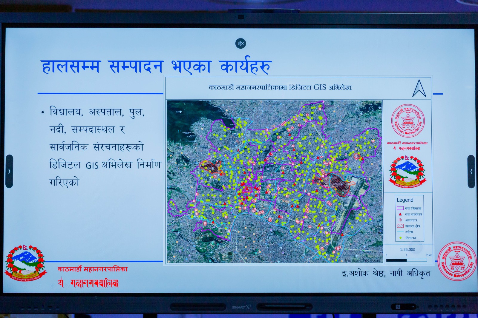
The metropolis has said that in the coming days, it will give priority to digital governance and location-based planning through drones and lidar, data processing and analysis. There is a plan to expand the use of GIS in smart tolls, road safety and traffic management, e-registration, social mapping, household survey, and other regular works. It aims to integrate land and building-related data into a single system and use it in planning and service delivery.
According to the provisions of the Land Use Act 2076, the Land Use Council has been set up under the chairmanship of the mayor of the municipality. The chief administrative officer will be the member secretary and the council will be a member of the executive committee.
Similarly, the Land Use Implementation Committee will be led by the Chief, the ward chair will be the coordinator and the ward secretary will be the member secretary.
The Act has provisions to classify the land into different areas of cultural and archaeological importance, industrial area, public use area, river, lake, wetland, commercial and residential area.












प्रतिक्रिया दिनुहोस्