

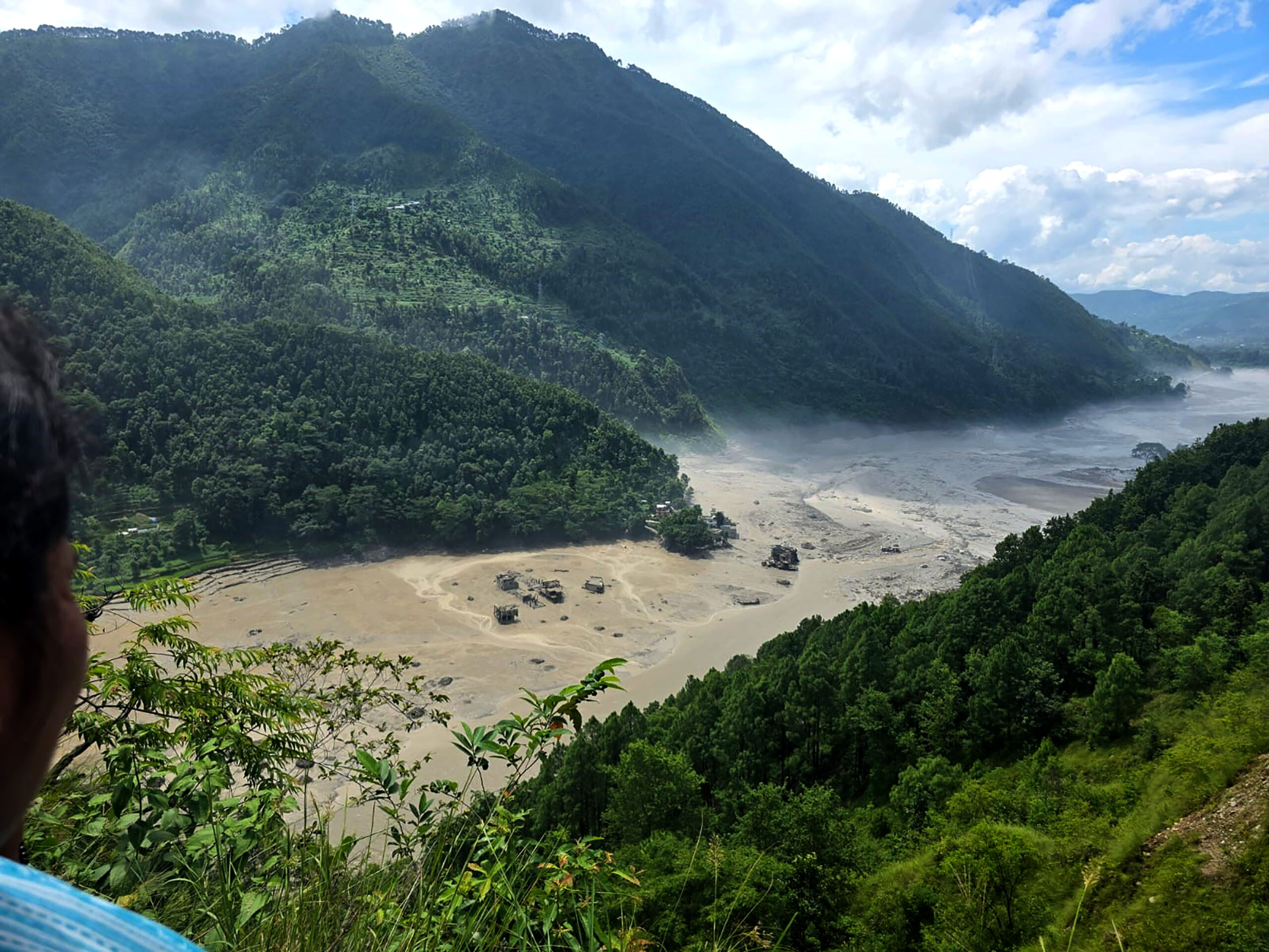
Kathmandu. Preliminary conclusions have been drawn that the intense and sudden floods in the Nde Khola-Tekoshi-Shuli-Rayani river system on August 10 were not due to rain but due to the landslide of avalanches and the subsequent displacement of debris.
According to the preliminary technical assessment prepared by the Hydrology and Water Resources Research Center under the Water and Energy Commission Secretariat, the flood originated in the upper catchment area of Lhende River, which is about 22 kilometers above the Nepal-Nepal border. From there, the flood flowed through Rasuwagadhi, Syafrubesi, Rasuwa, Nuwakot, Dhading, Gorkha and Chitwan before merging with the Narayani River at Devghat.
According to the report, there is no record of rainfall in the area around the time of the flood’s origin. Meanwhile, a 5.2-magnitude seismic event was recorded at 8:37 am at 28.271 degrees north latitude and 85.515 degrees east longitude. Based on data from the US Geological Survey in 2026, the report said that the seismic event could be related to the movement of glaciers and rocks and the process of debris falling.
Based on the analysis of the rainfall pattern and the lack of rainfall, it has been concluded that the floods may be the result of a gradual cascading effect created by glacial landslides and the subsequent displacement of a large amount of debris, not the surface flow generated by the rains.
The most unusual aspect of this flood is its extremely fast speed, the report said. According to preliminary information, the flood wave covered a distance of about 20 km from the source of the flood to the Rasuwagadhi border in just 7 to 8 minutes.
The technical analysis has confirmed that this situation is an example of very high flood-wave transmission. The speed of the flood is estimated to be about 188 km per hour up to the Rasuwagadhi border.
It is difficult to provide effective warning of flash floods in such high mountainous areas from the traditional rain-based flood forecasting system as the flood waves have reached the low-lying areas in a very short span of time.
During the floods, some hydrological measurement stations along the river corridor and their associated infrastructure were also damaged or completely destroyed. This also affected the ability to provide real-time data during floods, the report said.
The Flood Forecasting Division of the Centre for Hydrology and Water Resources Research had received information from the National Disaster Risk Reduction and Management Authority that a major flood had entered the Bhotekoshi river. After that, the information was also received from the local gauge reader at around 9 am.
After receiving the information, the Flood Forecasting Division immediately confirmed the incident with the local administration and activated the emergency warning system.
Immediate warnings and information were disseminated through official social media, SMS, telephone contact with Chief District Officer and concerned bodies, media and Facebook Live.
A total of 6,78,295 SMSes were sent through Nepal Telecom and Ncell from 9:05 am to 9:14 am.
These messages were sent to the people of Rasuwa, Nuwakot, Dhading, Gorkha, Nawalparasi and Chitwan districts near the Trishuli River corridor.
Continuous surveillance and warning was issued in the downstream areas as the flood wave moved towards Devghat via Galchi, Malekhu and Muglin.
When the flood wave reached Devghat via the Narayani river, the water level reached a maximum of 6.57 meters. According to the report, the water level at Devghat started receding gradually after reaching its highest point at around 4 pm.TAG_OPEN_span_40
According to preliminary hydrological assessments, an additional 20 million cubic metres (20 million cubic metres) of floodwater has flowed from the river stretch at Devghat.
After the August 10 floods, two more temporary natural barrier lakes have been formed in the upper reaches of the Lhende River. The report points out that if the natural barriers of these lakes are broken, there is a possibility of flash floods again.
Lake-1 is formed near the confluence of Lhende Khola and Lirung Khola. This lake is about 15 kilometers above Rasuwagadhi.
Similarly, the Lake-2 glacier formed in the upper part is near the collapsed area. It is about 21 kilometers above Rasuwagadhi.
According to the report, if the barriers of both these natural lakes are weakened and burst, there may be a possibility of flood waves again, which can create additional risk in the lower riparian areas.
This incident has shown that rain-based forecasting system alone is not sufficient in the high mountainous region and there is a need to develop an immediate information and warning system by incorporating glaciers, rocks, landslides, glacial lakes and sudden natural barrier breakdowns.














प्रतिक्रिया दिनुहोस्